Have you ever picked out a plant for your garden, thinking it will be the perfect fit, looked at the plant tag for its care instructions and been confused about the ‘zone’ listing? Don’t worry you are not alone. This article aims to explain what these zones represent, and why they are important to the plants in your garden.
Plant Hardiness Zones represent areas of similar environmental conditions. The USDA and Environment Canada have both independently and quite differently created graphic representations of these areas on maps. We break down the differences between the two below:
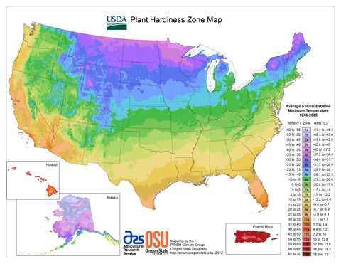
USDA Plant Hardiness Zones:
Probably easier to understand, the USDA measures Plant Hardiness Zones by average annual minimum winter temperature. The map is divided into 10˚ F areas, which represent the Plant Hardiness Zones.
Environment Canada Plant Hardiness Zones:
Unlike the USDA method, Environment Canada takes into account multiple Climate variables including:
- Monthly mean of the daily minimum temperatures of the coldest month
- Mean frost free period
- Precipitation from June to November
- Monthly mean of the daily maximum temperature of the warmest month
- Mean maximum snow depth
- Maximum wind gust
These variables get entered into an algorithm that gives a numerical value used to group areas or ‘zones’ with similar climatic conditions. Areas with similar conditions are said to belong to the same zone.
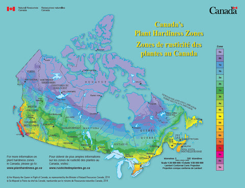
Each zone is given a numerical and sometimes also an alphabetical description. The number represents the specific Plant Hardiness Zone. The letter represents sub-zones within the greater numerical zone. These two methods however do not coincide with one another. For example, from the Environment Canada map, we see Toronto is listed in Zone 6b, whereas from the USDA listing, Toronto would be within Zone 5b.
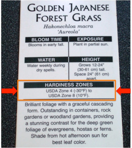
Ok, now you’re probably wondering what this means to you and your garden. Generally in both cases, the greater the number (and letter), the warmer the climate (e.g. zone 3a is colder than zone 7a; zone 5a is colder than 5b), with some minor fluctuations with the Environment Canada interpretation. Now this is a very basic interpretation of Canada’s Plant Hardiness Zones, but effectually does the job. This becomes important when choosing plants for one’s garden. Over time, plants have adapted to survive in specific environmental conditions. Some can tolerate cold better than others, or more precipitation etc. When looking at the plant’s ID tag, it should give you a ‘zone’ value. This represents the extreme limit of that specific plant’s range. For example, if we were to purchase a plant that shows ‘Hearty to zone 3’, this means that the plant will survive in zone 3 (the extreme limit) and all zones with greater numerical listing than 3.
Knowing our locations zone listing allows us to make more informed decisions on which plants to include in our gardens. If I live in Toronto in EC zone 6b/USDA zone 5b, I would not buy a plant for my garden listed as ‘Hearty to zone 7’ as this plant would either die or not perform well in my colder climate.
Another important thing to know is where the plant in question is coming from. If shipped from the US, it is likely that the zone listing coincides with the USDA values and vice versa for Canadian grown plants. Make sure you know your zone, and always check a plants range to ensure a lasting beautiful garden in any climate.
For more information and interactive maps visit the following websites:
Leave a comment